Yeah it might be interesting to try having two (or more) connected ocean floor patches at the bottom of a column, I wonder if all the species will end up much the same or if they will be different, especially if they are at different depths.
That depends on how many patch properties are we are going to take into account. Currently the only property that would affect cells is sunlight (and only photosynthesizers will take advantage of it) and resource avaiability, there are no organelles or adaptations that let cells adapt or take advantege of different pressures and temperatures and I think we should takle that if we want to make the most out of the patch map.
There were many cool ideas regarding membrane adaptations in this thread that I think we should look into implementing some of them, specially membrane fluidity (that would make temperature more important).
Unfortunatelly that means making more assets and coding more stuff, however we already have different types of membranes for npc cells so maybe that’s not too hard to implement.
Yeah I see the point. We’re not going to add a load more mechanics to this release because of the effort that would take and because it’s nice to test things iteratively before building further.
The things we can vary now are: sunlight, H2S, Iron and Marine snow, which should make for interesting combinations. Also we can vary ammonia and phosphates if we want, and also how things spawn (though that might be more work), like few big clouds vs many small clouds.
Even in patches with identical conditions it will be interesting to see how differently all the cells evolve, whether auto-evo makes them all the same or whether the eco-systems become radically different.
Sunlight doesnt vary yet.
1 Like
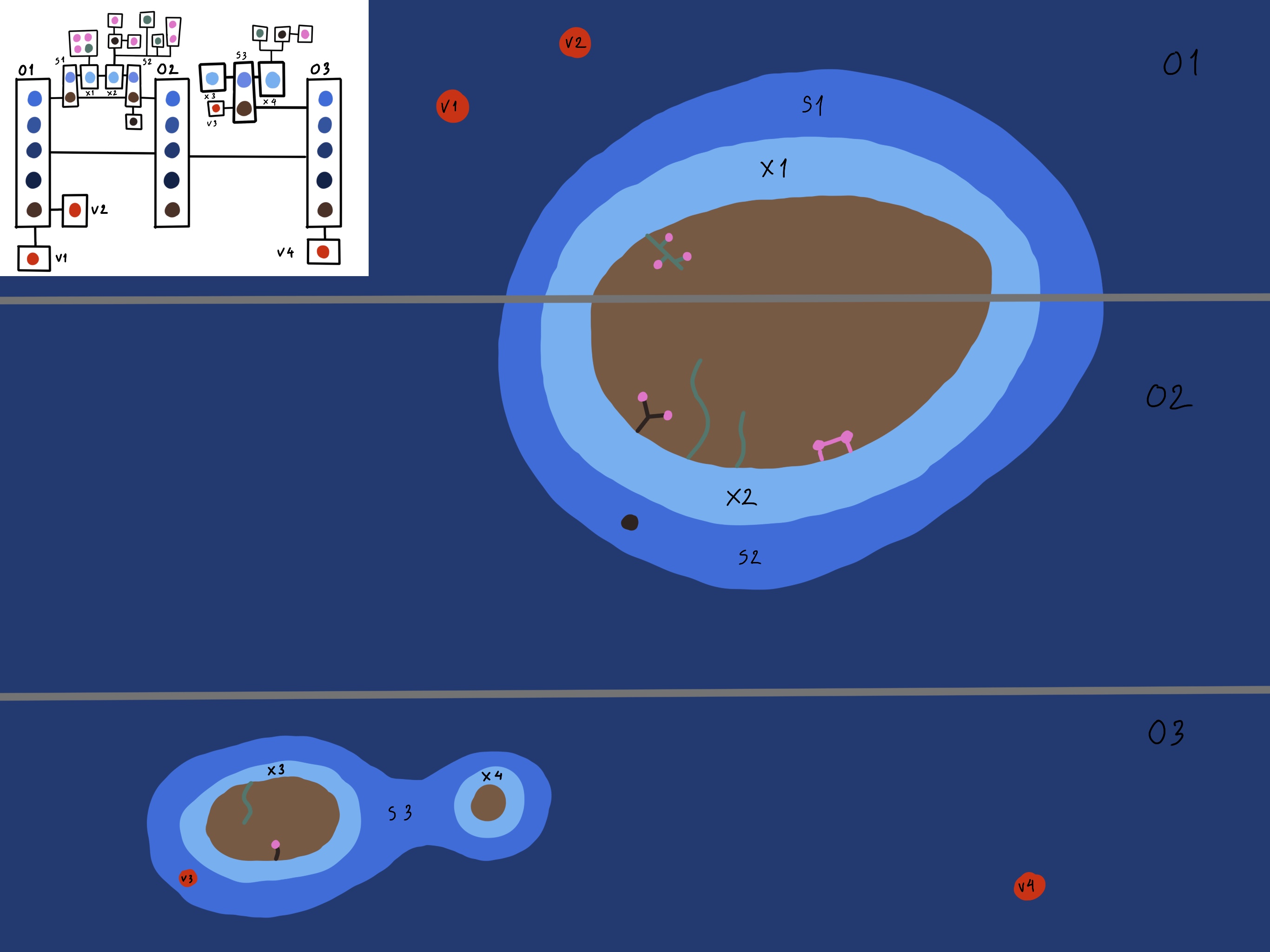
Here’s a representation of an ocean shelf which might be interesting.

Here it is with less patches and more floors per column, sort of as you were suggesting goro, I’m not so sure about it, not sure if I’ve captured what you were saying.
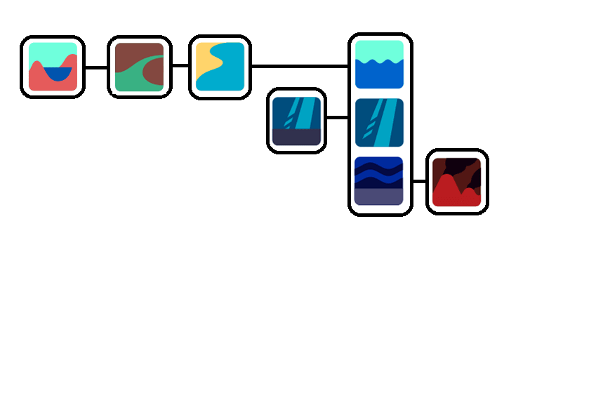
Yeah I’m affraid you didn’t quite catch what I proposed. I placed all the seafloor patches in another column and added a bathy patch.
I suppose the sea vent is on the bathypelagic floor, that’s why it’s conected to the bathy floor next to it and the bathy layer above. Maybe the sea vent could be on the sea floor column instead, since that way its conections would still be the same.
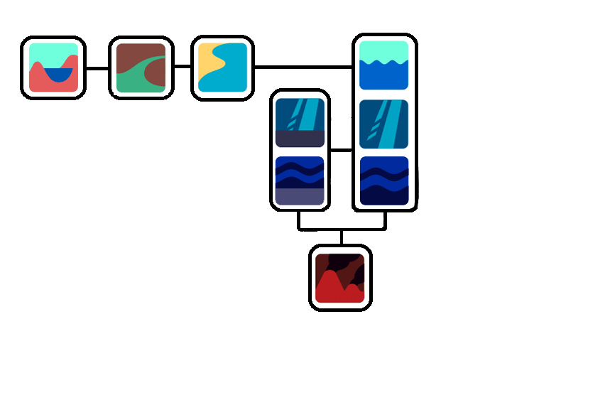
Ok I see what you mean. I’m not so sure about having two floors on top of each other, that seems a little odd to me.
They could be placed horizontaly under the regular sea patches, however i think that would mess the composition up.
This solution you proposed is also good, the only problem is that I think it would end up making too many patches and rectangles.
1 Like
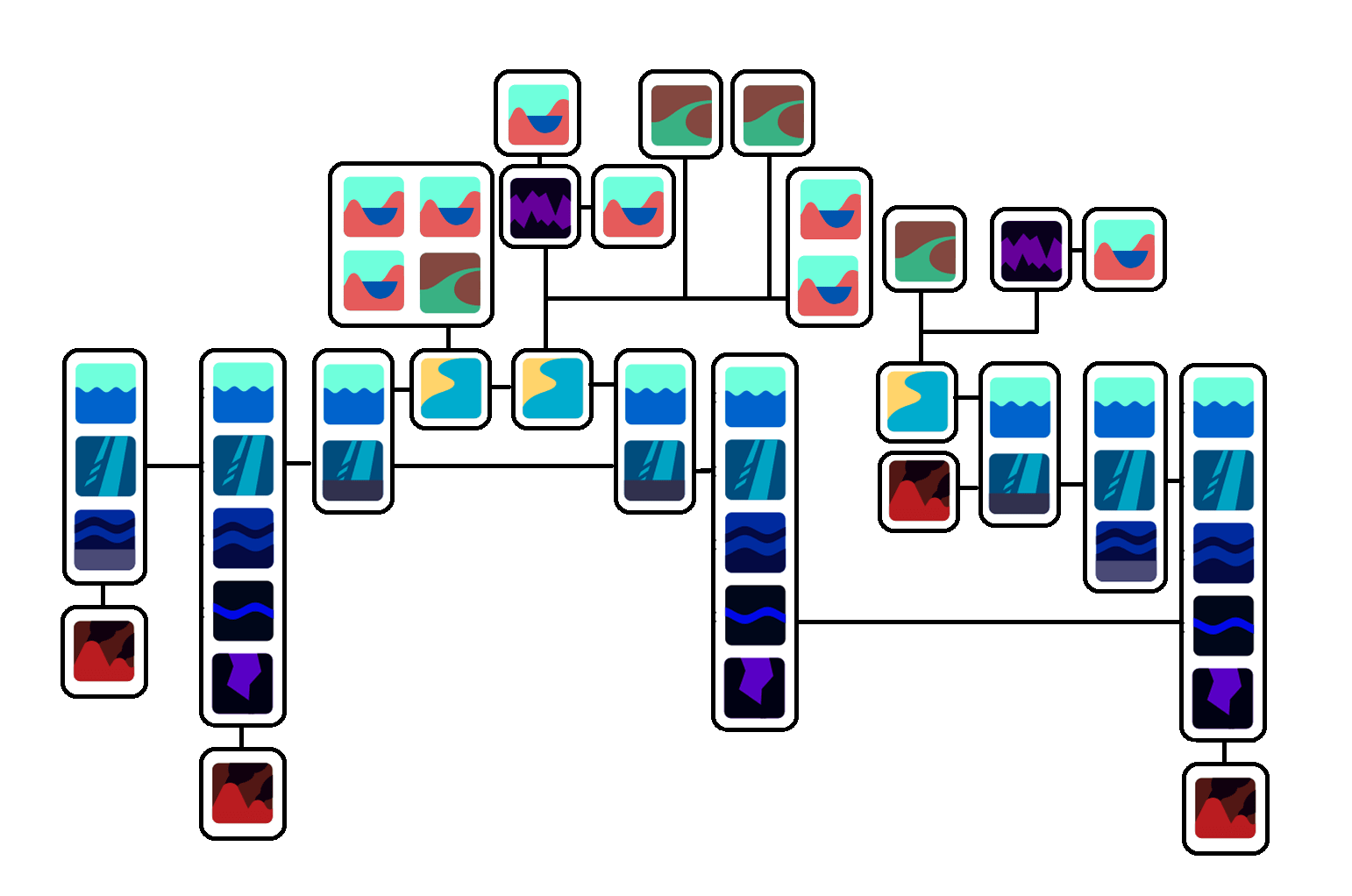
So as we‘ve recently discussed on Discord the plan is to make a procedual patch map generator eventually, but for the next release we‘ll stick to a pre-made map.
I‘ve done a quick sketch of such a map and included as many of tjs ideas from earlier in this thread as possible.
For a detailed explanation of how I ended up with my map open this spoiler:
explanation
I‘ve started from the assumption that the deep ocean is vertically comprised of five biomes: Epipelagic, Mesopelagic, Bathypelagic and Abyssopelagic.
My next assumption was that there would be some climate zones. I didn‘t want to make too many, so I made three: a warm zone around the equator and one cold zone on each pole.
That means there are already 15 patches without any vents, estuaries etc.
My next step was adding continents and the patches that come with them. I wanted to make two continents so there aren‘t too many, but more than one. The northern continent was to span over the northern and the equatorial climate zones. The southern continent was to only be surrounded by the southern ocean. This would help in making the continents differ from one another.
My next step was to determine how the shores of the continents should be connected to the oceans. First I tried to make the transitions as smooth as possible like suggested in many of the posts above. After adding some estuaries, tidepools etc, this is what I ended up with:
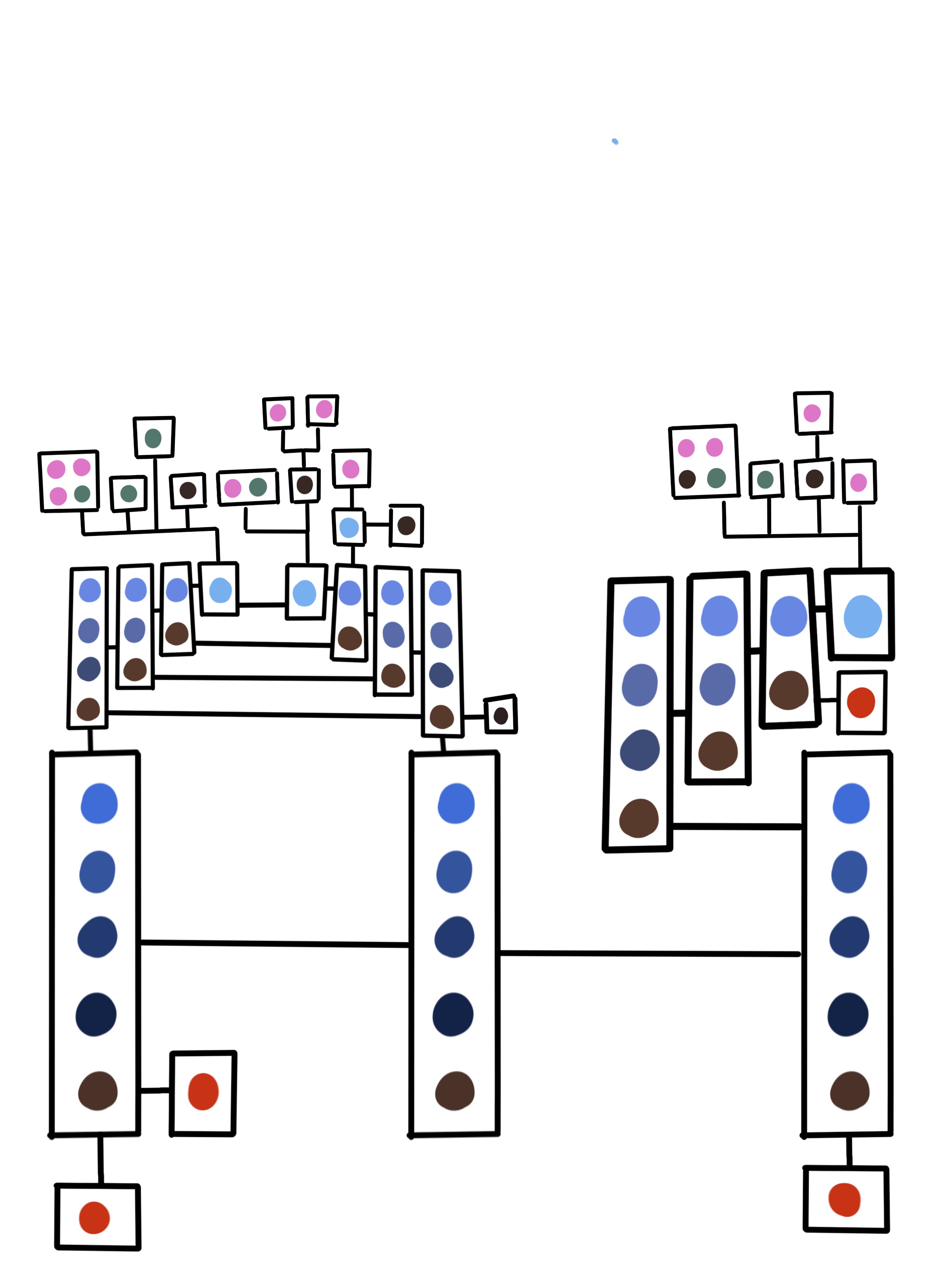
I felt like this would be too much. Because of this I drastically simplified the shore transitions. I‘ve found that in real life the transition between continental shelf and deep ocean is pretty abrupt anyways(https://en.m.wikipedia.org/wiki/Continental_shelf#/media/File%3AElevation.jpg), so I figured this might be a adequate sacrifice for the sake of simplicity.
This may start to pose a problem when ocean floor biomes get really different from other biomes. If species for example need a surface to latch onto like stentors they are going to have a hard time to move from floor patch to floor patch if they need to move through non-floor patches first. But as of now this shouldn‘t be a problem. (EDIT: I realized that this potential problem could also be prevented by simply connecting the deep ocean floor to the shelf ocean floor.)
With the simplified shore transitions the map now looks like this:
I hope it‘s more or less clear which biome each color represents. If not please ask!
This is a very simplified representation of what the planet would look like:
I‘m looking forward to hearing your criticisms and seeing your drafts for alternative maps.
1 Like
I really like it, I think that’s great. A few tweaks:
At the moment all the oceans are adjacent, if it’s like this then I guess all the life in the columns will be very similar as they will be quite well mixed. I think it would be interesting to break the middle left connection so if you want to go from ocean o1 to ocean o2 you have to go through a shallow sea s1. Imagine a band of land all round the planet maybe. That way there’s two large oceans connected so we can see what happens there and one which is a bit seperated.
I think it might interesting to have an ocean column of a shallower depth, maybe a small arctic ocean? It would also give an area which is almost always frozen which would be interesting I think, one of the vents could be moved there.
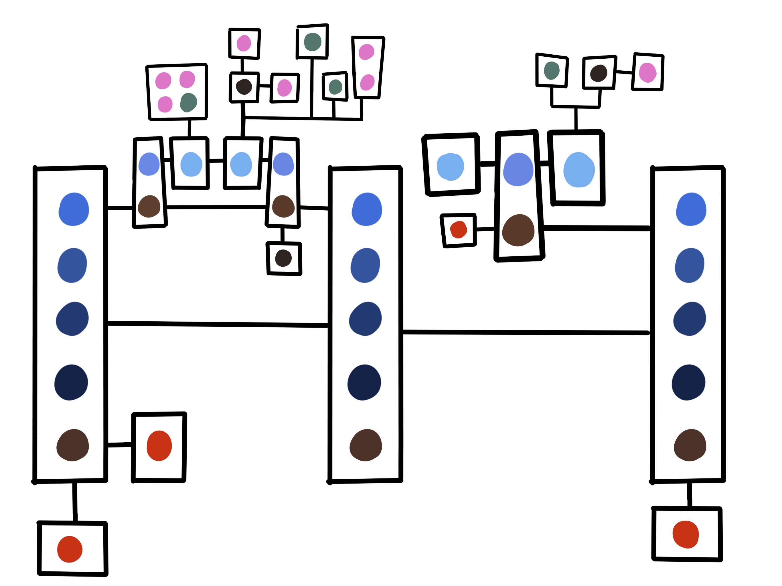
Here it is with those changes, what do you think? Otherwise it’s great. 
I‘m glad you like the general idea.
I have to say that a ‚band of land around the planet‘ sounds like somethig which is quiet unlikely to form. I mean I‘m sure it could, but it would have a very small chance. I think for the map we use for the first release with a patch map we should go for a more generic planet. That way the players know what to expect of the eventual planet generator on average.
The planet I proposed still has some quirks like the two tidepools connected by a cave or the vent on the continental shelf, but those quirks are in the details. All in all it is a rather generic planet, and that is very much on puropose.
I like the idea of the ‚shallow ocean‘ on the pole. As far as I understand that would basically be a completely submerged continent, am i right? I can get behind that!
The earth has something like a band of land thing happening around the Arctic Sea, you can see between iceland, the UK and Norway the ocean is shallower and deep around the Arctic and in the Atlantic. So I disagree that it’s an unusual feature.
I also think re ocean depths have a look on google earth, you can see there are areas of deep ocean and other areas (North Sea near the UK, the Sea north of Russia, the sea around Indonesia and north of Australia etc) which are shallower over huge areas. So I think it’s totally normal to have oceans / seas of different depths.
I think in general it’s much more powerful to pick out interesting collections of patches which will make nice, variable, play areas than it is to try and sort of average a planet into patches.
Edit: This is also quite interesting, if you look at an elevation map of Mars and you imagine it filled with water there would be a large ocean in the Northern Hemisphere and then a large continent in the Southern with a massive sea / ocean trapped inside it.
Edit 2: Another thing I think is interesting about planet is what percentage of the surface is covered in water. I guess if 70-100% is covered in water (Earth has 71% I think) there might be a lot of large oceans all connected to each other. If 0-30% is covered in water I guess you might expect several smaller, shallower, oceans which are less likely to be directly. It’s not something I’d really though about before, how water percentage impacts patch connections.
Alright, I see. In that case I‘m in favour of your proposed additions.
Ok great! Overall I really like your map, I think you did a great job with it.
I think you oversimplified it too much. Yeah the transition between the continental shelf and the ocean looks really abrupt when seen on a world map, but for a microbe (and probably any living being) the slope would be huge, so I don’t think we should remove all those patches. Besides, from the article you linked, in the continental slope there’s a lot of sedimentation wich means there will be a lot of minerals and compounds that organisms could use. Not only that but if there’s a lot of sedimentation there can be anoxic patches where there’s very low oxygen, creating more unique environtments.
I see the point. I think it’s too far the other way to represent a whole ocean with just 5 patches and then use 10 to represent the slope up to the shore. However I’m ok with adding a few more in on one of the shores.
We’re not going to really know how this all fits together until we can all play on it and see how it feels. So yeah I fully admit I don’t know what I’m talking about and we will probably have to redesign a lot of this stuff once we’ve played on it.
2 Likes
Here’s what the map looks like with icons. Goro I added a more smooth slope on the right so we can try that out. I hear you on the idea of adding more patches, we’ve got time between playing on it for the first time and the release to alter it so lets do another pass then, like it might be 10x too big already or something.
Mirror Monkey: What’s your intention with those “land patches” on the left side. There’s the cave, two estuaries and two tidepools all connected to a coastal. Is the idea they all touch each other, if so shouldn’t they all be in a box? Or is it that they all touch the coastal but not each other? If so is there a better way to represent it, it looks like you can just go from one of the estuaries to the 2 tide pools for example.
Yeah the map looks fairly big already. However shouldn’t there be another patch above the seafloor ones? For example, the mesopelagic floors have only an epipelagic layer above them, shouldn’t they have a meso patch too?
Oh I see, well I guess that convention could go either way. Like if there’s two patches is it epi with epi floor or epi with meso floor? I don’t mind particularly.
One thing I did wonder about is whether it’s wise to have so many floor icons as it might make it harder to learn the game. We could just have 1 floor icon for all depths. I don’t mind particularly.
I imagine the floor being the same “depth” as the patch above it, so a meso floor would be the floor at the bottom of a mesopelagic patch, an epi floor at the bottom of an epipelagic, etc.; so excluding the hadopelagic, which hasn’t really been planned as far as I know, the very deepest ocean floor would be an abyssopelagic floor.
As for icons, I suppose it’d be neater to use the same icon for all floors, but it’d also be weird to see a high-depth floor icon in a lower depth patch, or vice versa. Especially since each floor level has its own unique pressure, temperature, and sunlight levels, that make each as unique as the different water patches above them.
(also you’re still using the icons with poor contrast and using the hadopelagic floor icon instead of the abysso one :c )
1 Like