Sounds good. Yeah i just feel like we need a way of representing subregions without cluttering the map EG, the isolated bay.
I’d agree with DonGoro that the point of the map is just to show the adjacency of patches and nothing more (and not reveal any geography).
I would say that top-down is better because side view removes an entire dimension of information, since patches will often not be on top of each other. If they are on top of each other, we can use a simple visual cue like stacking them or something, but this will be much less common than patches being on the same line of latitude if we use a side-view.
However, since we’re trying to hide geography I don’t think this really matters. Like mentioned it would just be abstracted into a node and edge map like a subway map to show which patches are adjacent to which. I would suggest that for the map, we only ever show the patches the player is in and those that are adjacent, and nothing more. If there is a patch that the player previously was in and no longer is, or the population there evolved into a separate species, then we hide it again.
1 Like
I agree that the node map, of we use a node map and everybody wants that, should only display the connections between patches and nothing else.
This is a rough concept on arranging of nodes I did a while back:
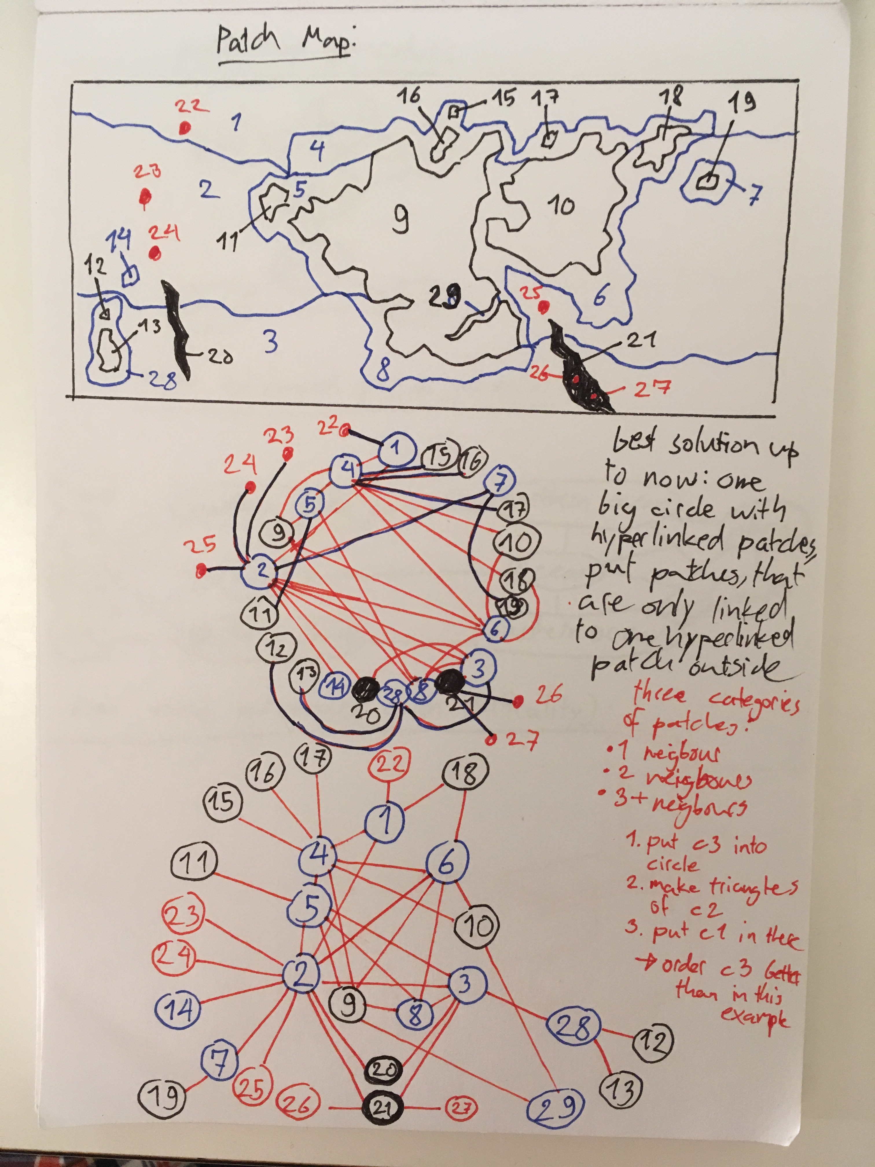
This is quiet a simple example as it doesn‘t account for depth. The idea is that there presumably are a lot of patches which only connect to one or two patches. These can be placed on the peripheriy. „Hyperconnected“ patches which connect to 3 or more patches are arranged in a circle so they can connect with one another without any overlapping or non-straight lines. The rest is then sticked to the outside of this cirlce.
If this shape was programmed to be geometrical and symmetrical, it could look rather neat. In this quick sketch it looks a bit shitty.
I‘m not sure how this model would deal with the additional complexity of depth though.
Does depth matter though? If we’re just looking at connections, and some patches would be separated by being at different depths, the node map should already be accounting for depth.
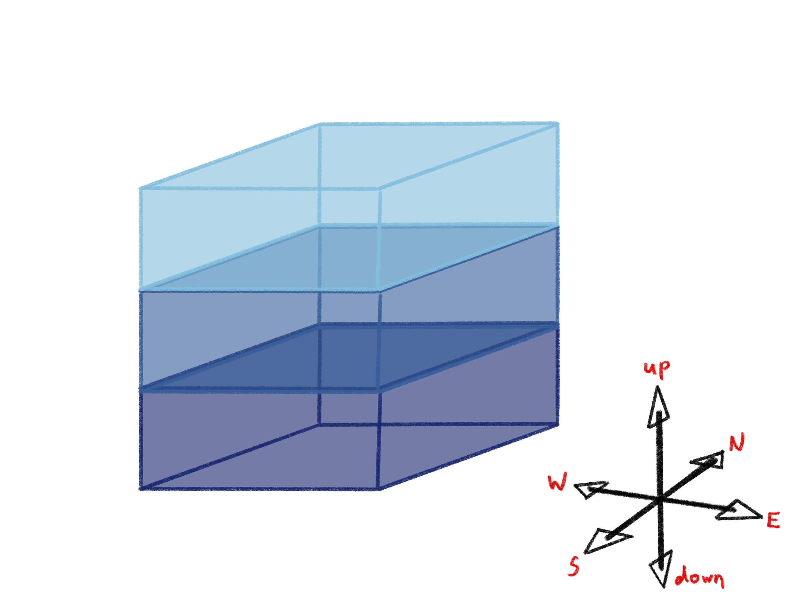
It matters in the sense that we know what biomes should appear at what depths (Epipelegaic (top), mesopelegic, bathylypelagic (Middle), abyssopelagic, and vents are at the bottom, etc.
Yeah for defining the ecological properties of the patches it would definitely be important, but visually however it shouldn’t affect the layout of the node map, since the differences in depth should already be accounted for by the connections between patches.
2 Likes
@NickTheNick No, that‘s not what I meant. I agree that you shouldn‘t display more elevated biomes at the top and deeper biomes at the bottom. I meant that my map/diagram doesn‘t show the vertical differenciation of biomes at all. The ocean on my map named „2“ shouldn‘t be one patch, but at least 3-4 because the ocean surface, mid-layers and ocean floor should be seperate patches.
Should we make that many ocean biomes tho? I agree that we should separate the different sea regions according to their light level and temperature, but what about the ocean floor? As I see it, it would be like a huge submarine dessert that would look pretty much the same everywhere. Would it make sense to separate it in different patches or should we consider it one giant patch instead?
If there are a bunch of neighbouring patches with pretty much the same conditions I think they should be treated as one for simplicity’s sake. Maybe it could have more room for organisms or resources could deplete at a slower rate since it’s a bigger patch after all.
1 Like
So I thought about climate zones.
On the vertical axis biomes are differenciated by depth relative to the ocean surface. What differenciates them on the east-west axis isn‘t entirely clear. On the north-south axis biomes/patches are differenciated by climate.
I suppose that warm and cold currents will be ignored for the moment. A finer gradation of climate zones means more realism and diversity, but also more required computational power and a harder time generating a patch map which is understandable and not too overwhelming.
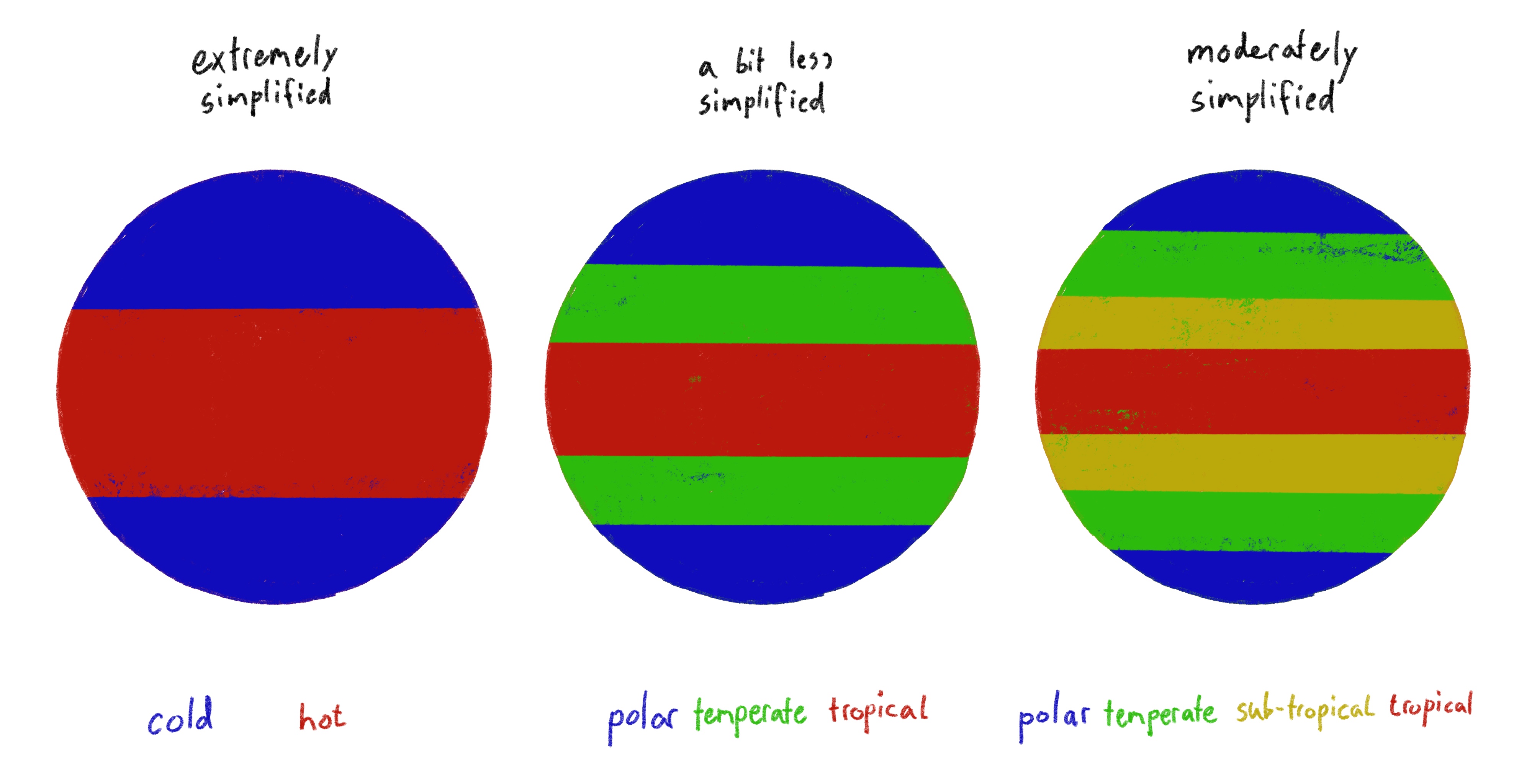
So how differenciated do we want to go with this? I‘m strongly leaning towards the side of „moderately simplified“, but that, coupled with depth and geographical barriers such as continents, will be exponentionally difficult to show as a comprehensive node map.
What do you guys think?
1 Like
I think its important to represent the ocean floor because the ocean floor is actually significantly different then just any other random ocean layer, and hosts very different creatures. And its important to seperate them out i think because x ocean might have different creatures on its ocean floor.
And the hydrothermal vent is also its own unique ecosystem. SO i think its important to seperate them, also, lots of microbes down there. So its especially different for microbes. Lots of svavenger gameplay.
https://www.mbari.org/tag/seafloor-animals/
1 Like
Then how about merging the bathypelagic regions of neighbouring oceans? Would a bathyal region from a temperate ocean be too different than it’s subtropical neighbour?
1 Like
@DonGororo As UntrustedLife already mentioned a very important resource in the deeper biomes is organic debris floating down from higher regions. Since surface biomes near the equator allow for more photosynthesis there will probably be more algae and other microbes feeding off these algaes in a warmer biome than in a cooler one. This in turn affects the abundance of debris in the patches below.
1 Like
Is the difference in the amount of marine snow significant enough to warrant having each climate zone have their own zones by depth? Especially as they seem to be pretty uniform in every other aspect once you get below the thermocline, such as in temperature. Also, algae needs nutrient rich water as well as sunlight; in my researching, most sources say that because of stratification warmer water is nutrient poor except for sites of upwelling. So, Equatorial waters wouldn’t necessarily have more amazing snow, right?
1 Like
Yeah, @stealthstylel, you do have some points…
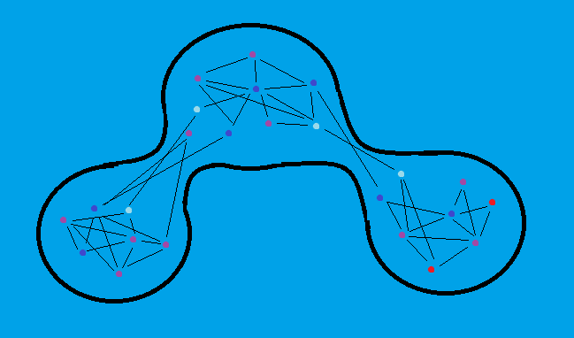
I‘ve done a lot of trying to fit maps I drew onto a node grid and what I‘ve found is that the problem isn‘t adding depth to the oceans. The problem are coastal zones.

This is an example of a map which I tried to display as one version or another of a node network. Biomes in open oceans connect to one another as a neat and tidy grid. But continents really mess everything up because they, together with the climate zones, fracture the coastal biomes into a lot of seperate patches. Arranging the patches on concentrical circles with patches of the same biome on the same circle and less hyperconnected biomes on the outside is the closest I‘ve come to designing a system that‘s more or less reliable. But it‘s still far from perfect…
The more complex the world map becomes the more trouble the patch map is going to make us.
1 Like
I’m trying to make an organized map of this and, hopefully, set the rules on how to build the patch map properly
2 Likes
Lots of interesting ideas here.
One question is about how many patches there should be in the map, 10, 100, 1000, 10,000 etc? I think it partly depends how fast life spreads out and how many different biomes we end up with. I think the map doesn’t need to be super vast, I think my prototype had a reasonable number.
Re connections one solution that has been mentioned here and I thought about is to only show connections from the patch you are in. That way if the connections are very dense then it doesn’t matter so much as they won’t be overwhleming. You can see that sort of thing in this demo.
One other thing is that I think depth is very important because sunlight is such a major driver. If you see the different maps this prototype generates you can see some have land and some don’t, and each one has the light level of the patches calculated by depth. I laid it out non-linearly so that the well lit areas take up more of the map so that there’s plenty of well lit biomes.
I think depth is rather more important than longditude because it really impacts what the patch will be like, whereas longditude is rather more arbitrary.
I agree with the point in general that we should have varied patches, so we don’t need a million different patches of essentially the same deep ocean. However when things are different and the life living there is different we should represent that.
3 Likes
Ok, i didn’t map all the patches because I didn’t want to loose my sanity. But i reached the equator, which is the most complex area and I’ve come to the conclussion that no matter what we do the complete patch map will always get cluttered.

But it doesn’t really matter that much, because unless the player somehow manages to spread and adapt to almost every biome, they will only see the nodes where they are and their neighbouring patches. Of course, the map will expand as they spread through the world so they will get used to its increasing complexity.
Regardless, If we want to build a patch map generator I guess we need some rules for arranging the patches. Here’s what I’ve come up to:
- Patches will be arranged from top to bottom: First, acording to their height; Second, according to their latitude (N/S).
- When two or more neighboring patches are on the exact same latitude (See the polar and temperate oceans) the northest patches will be put to the left of their neighbours.
- Longitude will come last when arranging patches (see the equator region on the patch map)
Also, something curious that happened when I was making the map is that I (unintentionally) ended up separating the patch map on regions. And maybe that’s something we should look into. TjWhale proposed this concept as a way to differenciate big clumps of nodes.
I think we could make a simplified version of the actual map that only showed the main regions of the planet and their main conections. Then you could zoom in in to see the map in more detail.
4 Likes
I also made a more traditional map-based approach where you can choose the biome depending on depth after selecting a point on the map. The player would reveal parts of the map around the area in which he’s in, kind of like in the Civilization games.
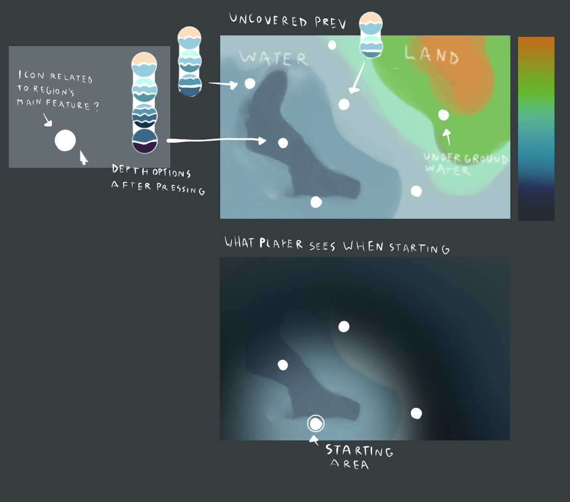
Points far away from the player would be hidden. Moving to different levels would be limited by one at the time so unaccessable by depth regions would be just marked as unavailable. Nodes would be shown when placing a cursor on the point. I think a regular map would be a much easier way to understand where you are on the planet.
I expanded on uniows idea, but instead of having depth options when you click, everything is instead at various Z Levels, so the map is in slices. And you can only be looking at one z level (Slice) at a time. And you “reveal” nodes you have been adjacent to, any completely unexplored node is invisible. Nodes your species inhabits reveal adjacent nodes (on your layer and on the layers above and below)
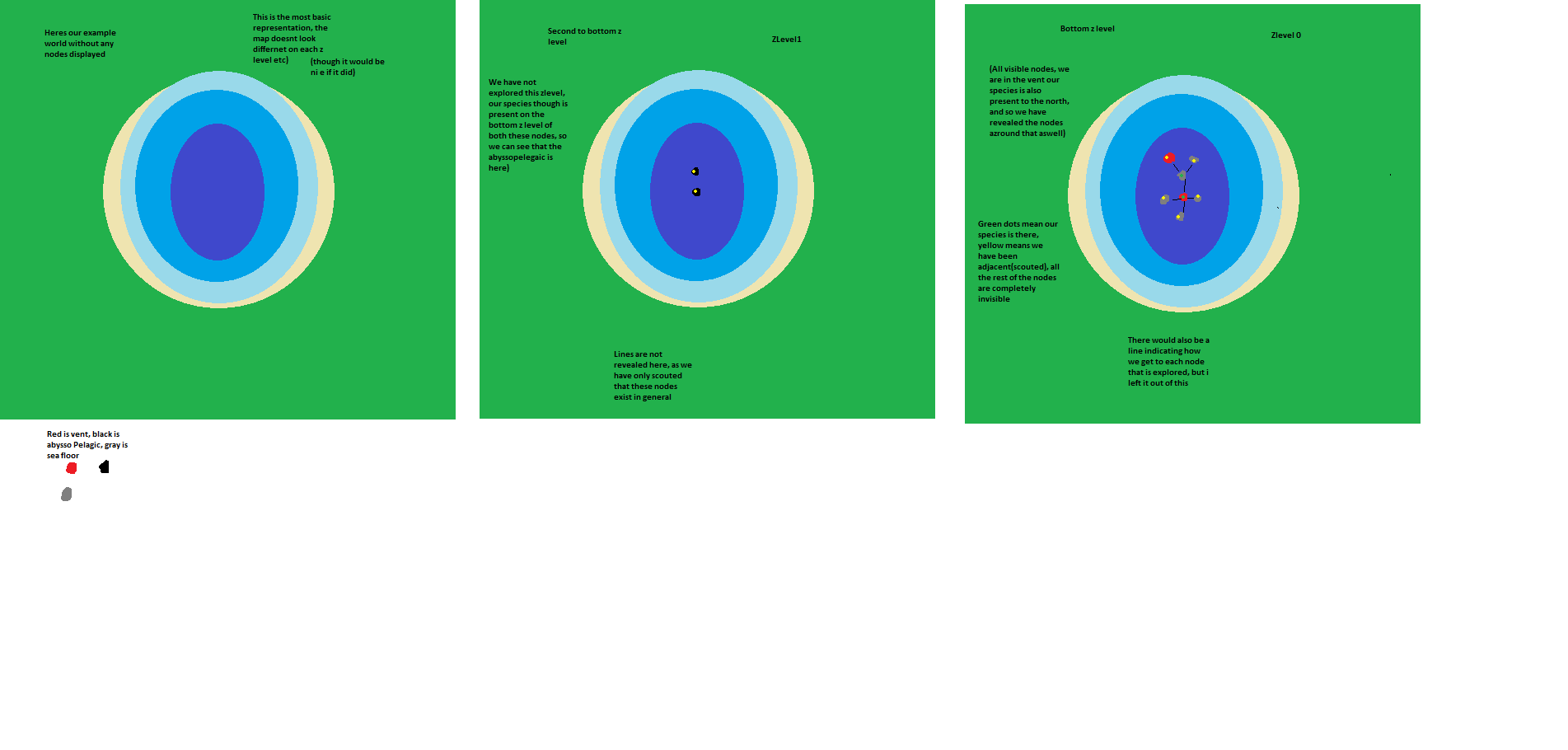
the green is meant to be land,
the middle bit is an inland sea
we are at the bottom of the inland sea
obviously there are several layers here, i’m ONLY displaying the bottom 2 for simplicity
Also, obviously only 1 layer would be displayed at a Time
As you can see our species is present on two nodes at the bottom level, since they are present they have revealed the nodes above them (Abyssopelegaic nodes that are at the same points as where all the nodes at the bottom area)
you could go up and down layers at will to look around (I only showed 2 layers here to show you the difference)
I explained the concept in more detail on discord:
(

![image|690x388]
(upload://wdOo99cSNbTtRQ7sBfLsPxI3XQp.png)


1 Like
Inspired by Uniow’s idea I made a new concept that’s essentially an hybrid between my previous concept and her’s:
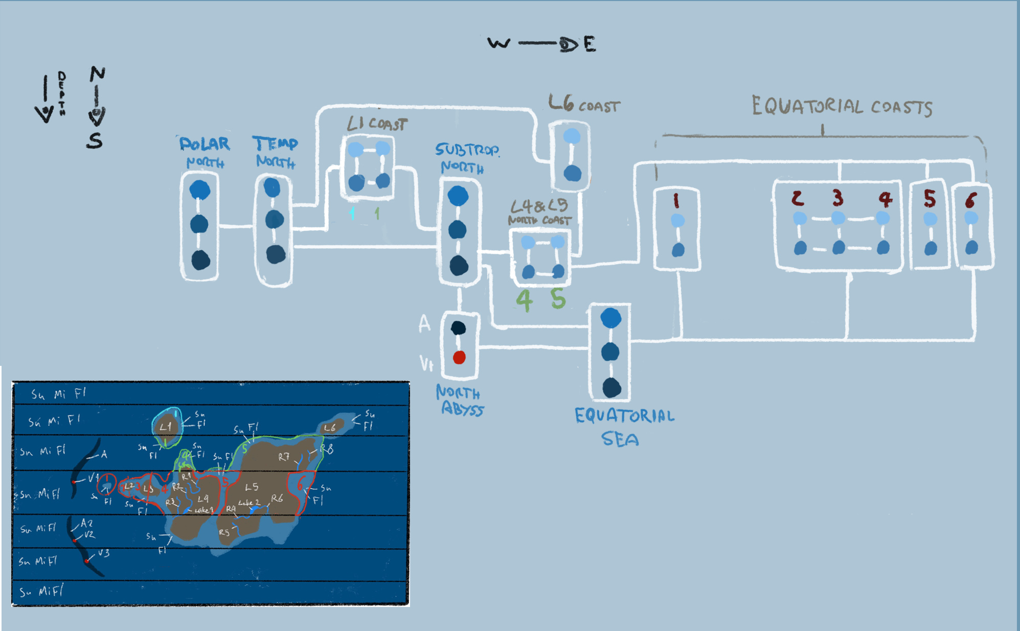
Here’s the full map, it’s the same as my last concept but this time patches are divided into regions and only the conections between regions and between the patches inside them are pressent. I guess patches will be clumped into regions if they are stacked one above the other (according to depth, like with oceans) and also if they are too interconected (see the coasts of L1 and the equatorial coasts).
But there’s more. If you thought this map was simple then look at this:
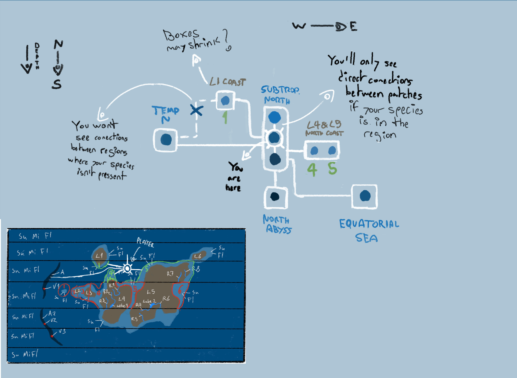
This is what the player would see. Assuming they are in the mid region of the subtropical ocean they could go to the adjacent oceans too, but only to their mid regions, since those are the only ones where they could travel directly.
Essentially, patches will still have individual conections like in the first concept but only conections between regions will remain visible.
Also, if two adjacent regions (or patches) happen to be interconected, the player won’t know about that until they travel there.
I think we could use the same rules I made for my previous concept for this one too, although maybe we should smake a few more for clumping patches into regions.
1 Like