That looks pretty nice, I like how clean it is. An additional option would be to colour code the connection lines to show that some patch groups are connected only on certain levels.
I think re z-levels UntrustedLife, and clicking on icon stacks Uniow, I think it’s preferable if we can get all the info on screen at one time, rather than having to have navigation through the map. If it’s unavoidable then it’s ok but if there is a way of just displaying everything in one go I think that’s cleaner.
Ok after 40 posts in 3 days I think it’s time to use my designer powers to move this discussion on a bit. It’s been fruitful, thank you to everyone who has contributed, loads of great points and ideas. Here’s what we’re going to do.
For each planet there will be a set of planetary variables. These will be things like: light level, global temperature, percentage of surface covered by land, deepest depth of the oceans, atmospheric gas concentrations etc.
For the microbe stage we will use these variables to generate an abstract node and line patch map which has no underlying geography. This means it represents the planet to a degree, for example if the planet has no land there will be no land on the patch map, if the planet is completely frozen then all surface patches will be frozen etc.
For later stages (certainly by the strategy stages and maybe before) we can generate an actual geographical map with weather and accurate placement of deserts etc and use that as the actual representation for the planet.
The reasons for this are as follows:
It gives us an easier place to start for this stage to get something done without a lot of complicated world generation. Moreover because both the patch map now and the later geographical map are based on the same planetary variables they will match reasonably well, for example if the planet is all ocean both will show that.
We can still have cool planetary effects, maybe connections between patches can break and no ones can be formed. The temperature of the planet can change so patches freeze or unfreeze, the star’s light can change intensity, the gasses in the atmosphere can change which can change the planetary temperature etc. An asteroid can strike and have a widely felt impact.
We leave the door open to more advanced geographical stuff later, hearing people be excited about weather patterns and plate tectonics etc is great and we can still do all that in a later stage if we want to.
Generating a node and line map from scratch means we can make sure it looks nice and has a clear set of connections, I think if we make a tangled web that’s going to be not so attractive.
I hope everyone feels like their opinion has been heard, I have tried to listen to everyone’s, and it’s now decided.
What remains to discuss is how we’re going to do the node and line map, and moving from there to making a prototype of it. I like dongoro’s map, that’s pretty cool, we can also do something with blobs or a general network. I think it would also be nice to have icons for each biome rather than just nodes, I think that will be visually nice so we should design them, Uniow’s ones with more wavy lines for depth are pretty cool. I also liked Naro’s designs that have clusters of nodes and things like that, I think that could make for some interesting gameplay.
The map should have rules about connections, like you can go from tidepool to coastal but not from tidepool to abyss etc so we need to sort that out too.
I made a quick prototype along similar lines as Goro’s but using circles more than sqaures. I don’t love it but I do think it’s kind of interesting. The colours are totally random.
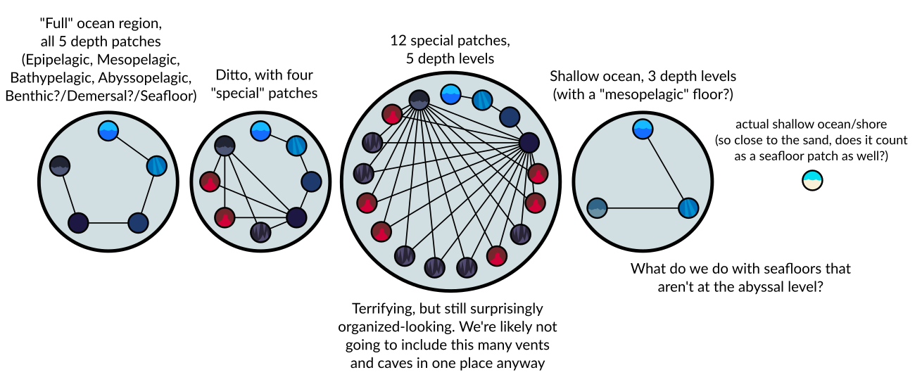
Nice work, but I don’t think placing patches in a ring-like pattern is a good way to represent the depth of the region. Also, I think boxes (or whatever shape we end up placing patches in) should have a limit on how many patches they have so it doesn’t get too cluttered. I’m not saying we should remove the leftover patches either, they could be clumped in a new region. In fact, we could separate regions according to the type of patches they have:
Abyss for the hadal zone and sea vents (tho maybe those could appear on the seafloor too?)
Ocean for epipelagic, mesopelagic, bathypelagic, abyssopelagic and seafloor patches
Shallow ocean they’d have the same type of patches as normal ocean regions but obviously they’d have less depth. Also we may have to make new types of seafloors since they can be at any depth.
Coastal for estuaries and tidepools (and any new biome that is in contact with dry land like rivers or even aquifers).
Biomes like caves and ice shelves (and maybe sea vents) could appear in any region, as long as it makes sense (you won’t see ice shelves on a subtropical ocean) and their properties should be coherent with the region they are in (a sea vent located in a shallow ocean (not sure if that’s possible) would have a higher light level than one in an abyss).
Back to your concept:
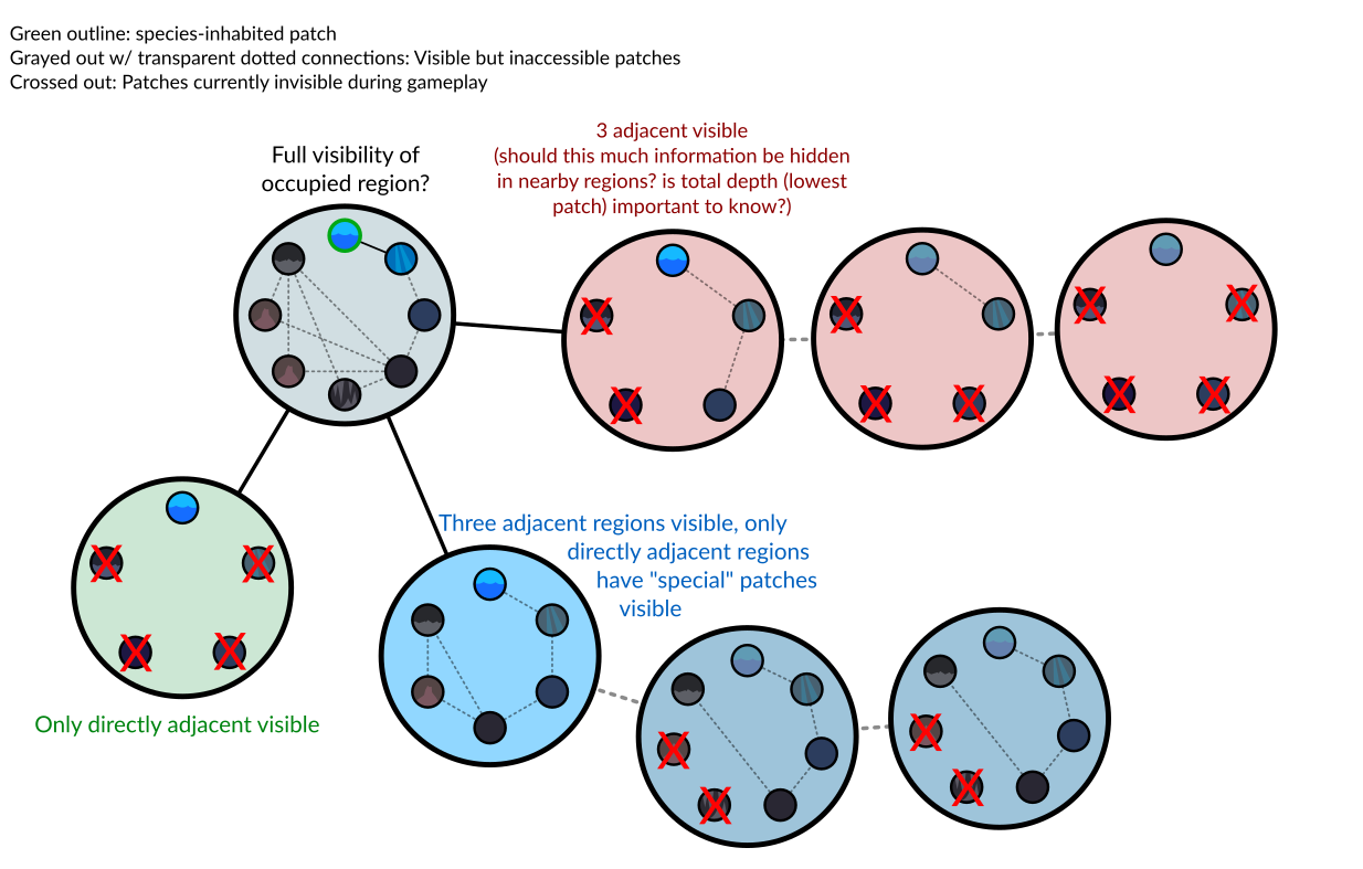
I don’t think you should see more patches than the ones your species inhabits and the ones directly adjacent to them, and the same applies to regions. But one thing we could do is this:
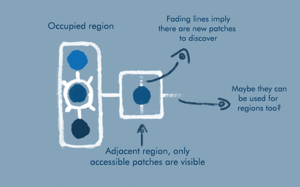
We could show fading lines on unocupied patches and regions, this would imply there are more patches conected to the ones you already see. However, I think showing adjacent patches is a good enough incentive for the player to explore their world. They’ll start at the botom of the ocean after all, so they will understand this mecanic once they ascend to the abyss and see that new patches appear on their map.
Yeah interesting points. I think the idea of clustering the biomes is an interesting one. Having rectangles for deep ocean, others for shallow and then others for coastal and land patches does make sense I think.
Here’s another example with more rectangular patches. The connections are still a bit of a mess.
All feedback welcome, is this a good direction to be heading in? This isn’t particularly how I imagined the patch map originally however I think this approach might pay off. It could look quite cool I think.
It does look cool, not sure I fully understand what’s going on with it though. Are there some regions that don’t have any higher-depth patches above them?
Atm this is just procedurally drawaing a bunch of boxes with blobs in and connecting them with lines. So yeah it doesn’t really mean anything yet I think.
We’d have to work out rules for which patches can go in the same box as others, when boxes are connected, whether those connection lines can cross, how far they can go etc.
Well that’s weird because it looks like that previous concept you posted follows pretty much the same principles as mine.
I’ve noticed that there are some errors on my map tho: the green 4 and 5 patches shouldn’t be on the same region since they aren’t actually conected with eachother. Maybe that’s what confuses you?
Also keep in mind that this map only shows the patches on northern hemisphere, I could make a complete map tho if that helps you understand it better.
Perhaps, I mean I see a region that’s just an abyss and a vent, and you suggested separating regions based on what types of patches it has, and I’m not sure where the patches directly above that abyss are if there are any
We could put a bunch of nodes down on a plane and then connect them up with lines, that’s kind of what I did with this prototype. It works and I’m a bit concerned it will end up as a tangled web of lines that is a bit confusing. We could do a Delauny triangulation on it or something, that would be reasonable.
So I think one possible solution to that is to group the patches into “regions” ( a circle or rectangle which contains a bunch of patches) and then have a rule that you can move from any patch in a region to any other, i.e. they are all densely connected. Moving from one region to another is a bigger deal.
The regions could be things like a column of water in the ocean or they could be more horizontal / thematic where maybe a vent, some ocean floor and a couple of deep oceans are together and then somewhere else there’s a coastal and a few tide pools all grouped together.
I think this might make the map easier to read by reducing the number of connections quite a lot and might look quite nice, though that’s much more your department than mine.
I’m not thinking every time a deep ocean patch is present then automatically it includes the whole column of water above it, but that would be possible.
The patches above the abyss are in the subtropical northern ocean. Of course, that abyss is also conected to the equatorial ocean which, now that I think of it, it should be above the abyss as well. I should make a cleaner version of this in the future.
Making horizontal regions could work too as long as they don’t have to many patches, they shouldn’t get too wide.
The thought of being able to move freely within a „region“ really doesn‘t feel right to me. That basically means that you just could skip from the abyssal area to the surface, without having to inhabit the mesopelagic first, right? The map might look nice and clean in that case, but this really feels unrealistic to me.
This proposal of @DonGororo would be ideal I think. Everything would look nice and clean, but you couldn‘t move from the ocean floor to the surface or anything like that.
Yeah that’s a good point. I agree there should be rules on which patches you can move between and if they are very far apart in depth it makes sense you need an intermediate step.
I think what we’re really trying to do here is to teach a computer how to draw nice patch maps when given planet variables. I think this is an interesting project because it needs all of our skills to be pooled to produce something really good. It’s got to look nice (art team), respond to the changing planetary variables smoothly (programming + theory), a computer needs to have a list of rules from which it can draw the map (programming + theory) and it needs to have good gameplay (gameplay = everyone). I think we’ve got the potential to make something pretty great which is better than anything any one of us could produce so thanks everyone who is contributing, I think this is a cool process.
I like your thoughts goro about working out a grid pattern for how to layout patches, that’s the sort of thing we need to do, have a list of rules from which the map is drawn.
Re geography I think it’s helpful to detach from the idea of geography as that actually gives us a lot of freedom. I haven’t had time to prototype this yet but I think one idea that might look great is if we start in the middle of the map, put down a region (rectangle maybe). Then iteratively we can put down a new region near those already placed and connect it with lines to those that are already there, such that the lines don’t cross. This means it will grow kind of like a snowflake or something which I think could look really good.
On reflection I like the idea of vertical stacks of ocean patches because of the marine snow , as you were saying Naro. The main energy source in mid ocean patches, where it’s too dark for sunlight, there’s no H2S source and no iron will be debris falling from above, so having the patches in a stack makes computing this really easy.
I also wondered about maybe different thicknesses of connection? So some region to region connections are really easy to cross, shown as thick lines, (maybe between two close regions of ocean) and maybe some are hard to cross, shown as thin lines, like into an underwater cave with a narrow entrance. Might add some interest to the flow of species. Maybe when you move some of your pop to the new patch less of them make it through a thin connection. Anyone have thoughts about that?
Here’s an example of what a growing map might look like. I put some 45 degree subway lines in, not sure if people like that. (Looking at it again it’s not such a good example as if red is abyss and green is tide pool then they definitely shouldn’t be connected, but you get the idea.)
Then the entrance should be really narrow wouldn’t it? We are talking about microbes here xD
But seriously, this is an interesting idea, maybe ocean currents could gate the way to new patches?
Also, what would be the incentive for the player to leave their cozy sea vent? If I recall correctly, that kind of patches would have a lot of resources, but the ones above them would be more barren. Maybe once the vent gets overpopulated they will have to venture outside? Or maybe all patches will start with a high level of resources that will decrease over time?
Yeah Crodnu brought that up and I thought it was a good point, we should encourage spreading. I like the idea of an overpopulation penalty, where if you have a lot of pop in a patch it becomes harder to get more, which means you are incetivised to spread out, also yeah having starting resources in each patch means getting out early is good. So both nice ideas there.
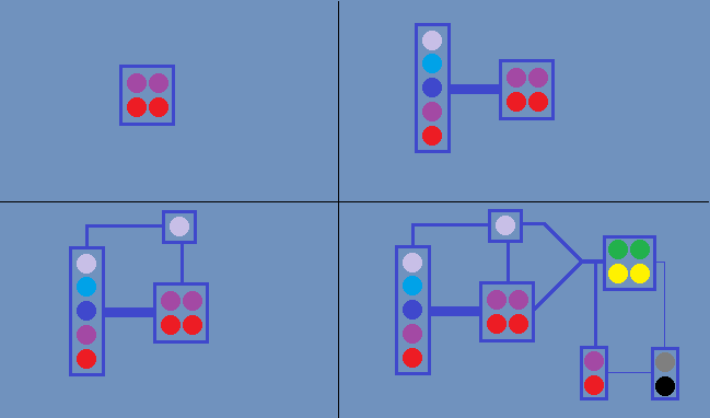
Ok I did some more work on the prototype today. I implemented a new generation algorithm which has two nice properties, none of the connection lines cross (though they come close) and all the patches are certainly connected to the network, which I think are kind of important.
I think the improvements that might be good for this release would be things like:
implementing rules about which patches can be connected to which
things which it’s probably best to leave for a later release
different strength connections
connections changing over time, forming, being broken etc
Is everyone ok with this being the design we go forward with? I guess this is probably a good time to check in case anyone wants a major redesign. Personally I am reasonably ok with it, I think it’s not quite visually strong enough yet but we can work on that, also I think mechanically it will be fine. Have a think about it and lets see if we’re all happy enough with it.
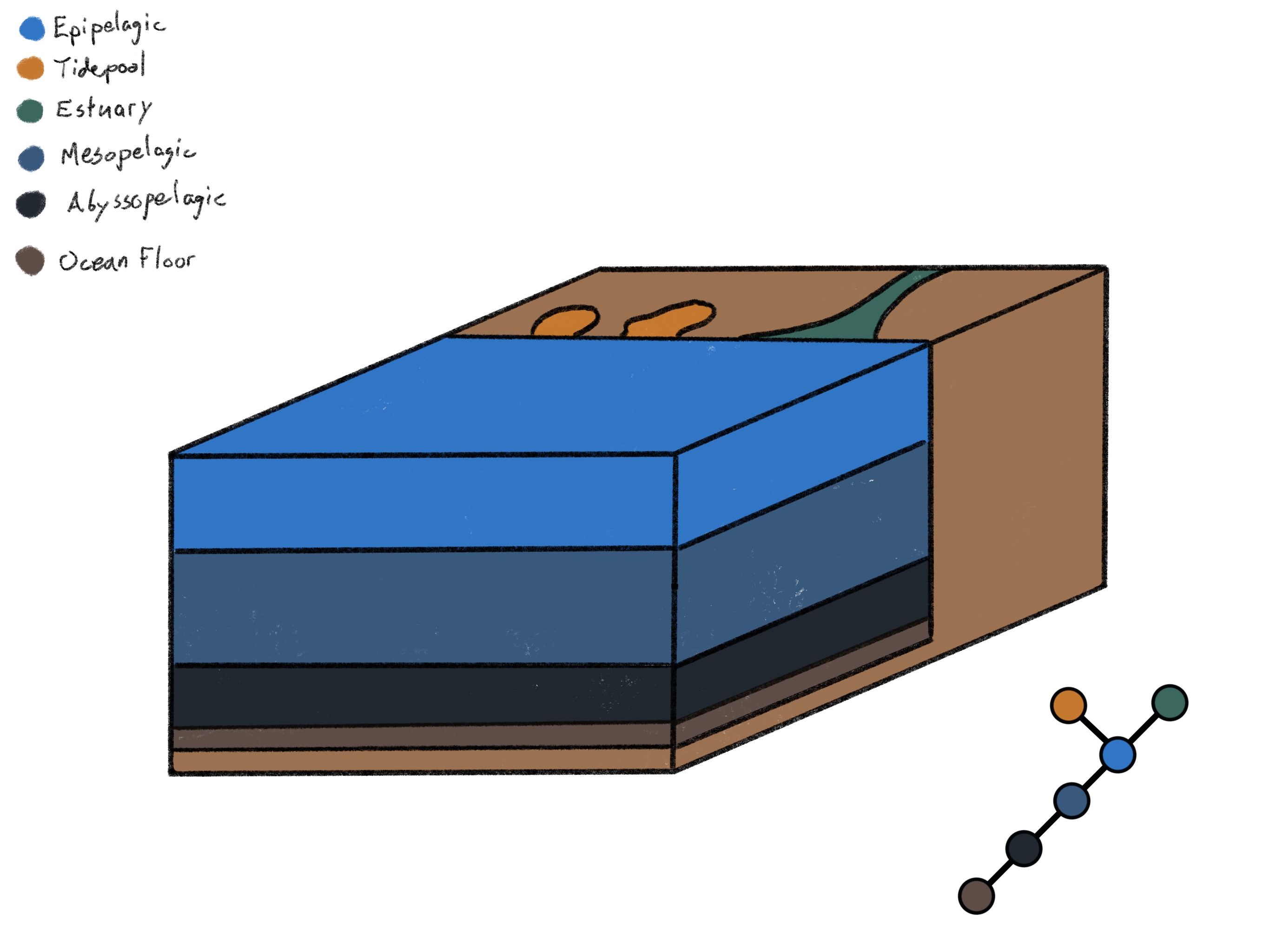
Things like saline seas, underwater caves etc. can wait, but there is one problem I think we should solve in this release: Making the transition from deep waters to shallow waters more gradual.
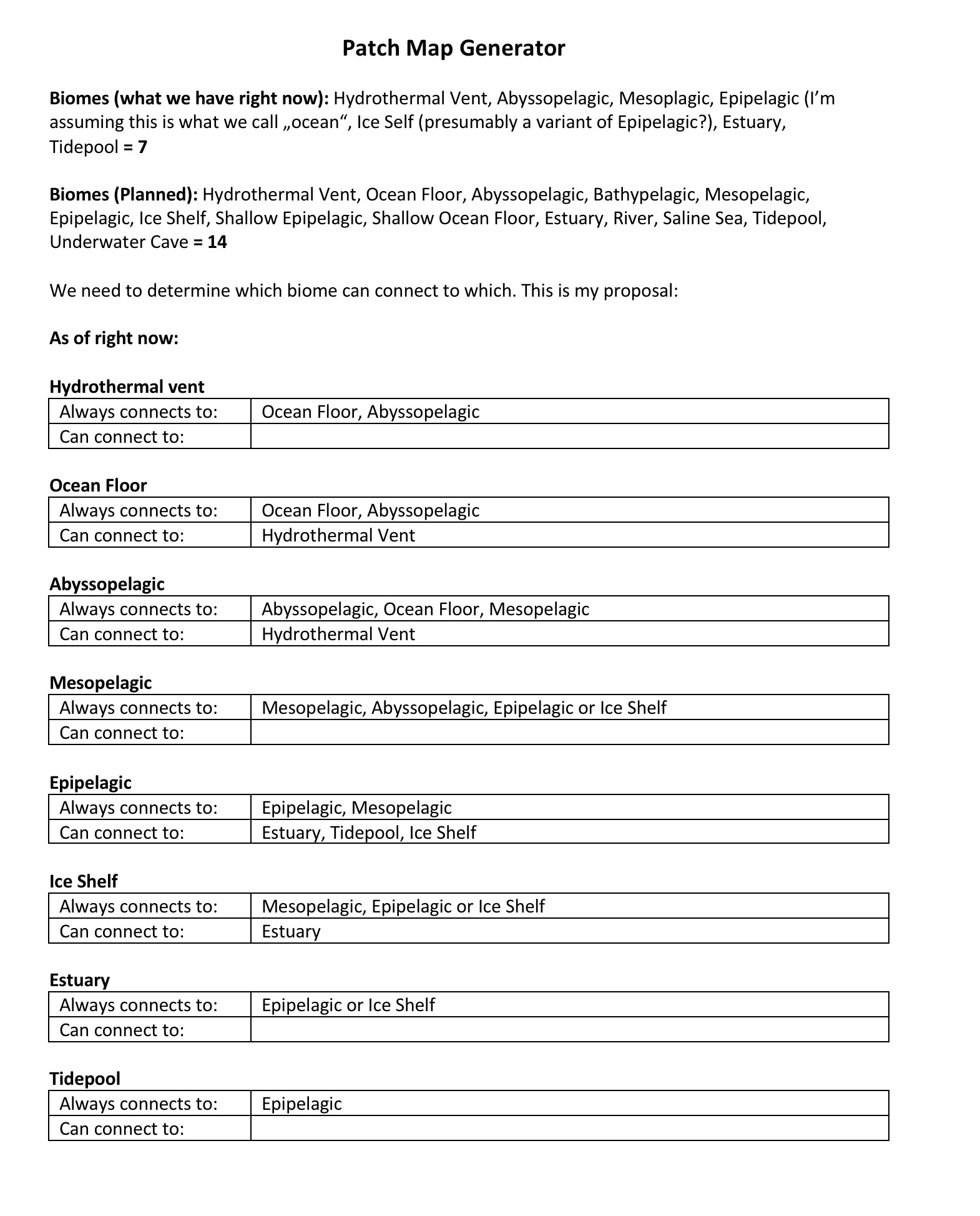
With the addition of a bathypelagic biome (or do we just summarize abysso- and bathypelagic as one biome?) this is the smoothest transition I can think of:
Now this is probably way more complicated than necessary. Somewhere in between these two images lies the optimal input/output ratio. The question is: Where exactly?
 It’s been fruitful, thank you to everyone who has contributed, loads of great points and ideas. Here’s what we’re going to do.